
In the wide Qazvin Plain, the Sagzabad Cluster consists of three prehistoric tells, located within 2km of each other and forming a settlement sequence. Although the sites were studied individually in the 1970s, their relationship is still not fully explained.
The tells of Zagheh (early chalcolithic, 6th and 5th millennium BC), Ghabristan (late chalcolithic, 4th millennium BC) and Sagzabad (Iron-age, 2nd millennium BC) lie 52km south of Qazvin and 132km west of Tehran in the Qazvin Plain, which forms the western part of the Central Iranian Plateau. The plain is bounded in the south by the Ramond Mountains from which, since prehistoric times, downwash has led to considerable soil deposition in the plain. Excavations have shown that at Zagheh the virgin soil is 6m below the current level. The top of the mound, 0.5m above the plain, dates from the fifth millennium BC. Malek Shahmirzadi (1977:35) reports that at Sagzabad 5m of alluvium have been deposited since the 3rd millennium BC. On the tell of Ghabristan, Iron Age graves were found about 1.5m below the current surface, and 50m away from the mound, magnetometer surveys discovered an ancient irrigation channel, capped by gravel lenses, approximately 0.6m below the current ground surface (Schmidt et al. 2005). These findings demonstrate the complexity of the stratigraphic sequences encountered between and on the tell mounds. The sketch plan of Neghaban (1977:Plan 5, see below) provides a simplified section through the tells of Ghabristan, Sagzabad and Zagheh (from left) and the presumed alluvial deposits between them.
Click picture to enlarge
It was initially reported that "the archaeological strata in these three mounds complete each other" and that "Ghabristan was occupied when Zagheh was deserted" (Neghaban 1977), but their relationship was not further explored. Recent radiocarbon dating (Fazeli et al. in press) has revealed indications for a shift of occupation from Zagheh to Ghabristan without much overlap at around 4200 BC (occupation in Zagheh from 5370-5070 BC to 4460-4240 BC, in Ghabristan from 4200 BC to 3200-3000 BC). However, the site of Sagzabad seems to have only been occupied from 2100 BC, leaving a gap of 900 years to the apparent abandonment of Ghabristan. Some earlier reports state (Neghaban 1977) that archaeological layers of the late second millennium BC were found both at Ghabristan and Sagzabad and may be related to the use of Ghabristan as a burial ground for Sagzabad. The modern radiocarbon dates are therefore not in full agreement with the original excavation results.
The fine textured alluvial soil in the plain is fertile and when irrigated, extensive agriculture can be sustained. Even some dry-farming has been reported (Malek Shahmirzadi 1977:29), which may also have been practised in prehistoric times. A reconstruction of past environments, both natural and agricultural, will be of great benefit for the understanding of the tells' societies. The potential for such environmental studies has hence to be explored.
Click picture to enlarge
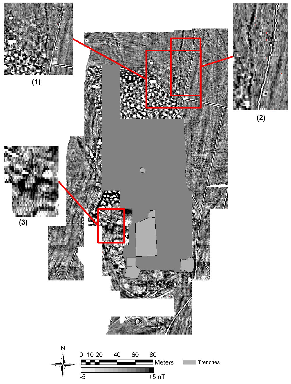
The Iron-age graves found at Ghabristan are within the current plough-zone and have been heavily looted, leaving a crater landscape. Over the last years several excavations have investigated other parts of the site and revealed its deep stratigraphy. Of particular importance are metalworking finds from the chalcolithic period.
Magnetometer surveys of a 6ha area were undertaken to identify the extent of the tell and any associated features. The robber pits in the central area produced pronounced negative anomalies and any potential features below them were undetectable. Outside this disturbed area important discoveries were made. Several pit-like anomalies were detected adjacent to the illicit excavations (1) and it is likely that these are related to burials that may still be undisturbed. In addition, the outlines of irrigation channels (2) were detected. They appear to be much more curvilinear than the straight irrigation ditches used in modern times. Upon excavation, one of these was found to be buried by ca. 0.8m of gravels and silt, at a similar depth as the looted Iron-age graves. In addition, the magnetic anomalies of the Iron-age graves and of the channel are intertwined so that they are most likely contemporary.
Most of the formerly excavated areas were not backfilled, which allowed to conduct magnetometer surveys closer to the earlier occupation levels. The data revealed distinct rectilinear anomalies (3), which resemble the chalcolithic metal production structures that were reported from adjacently excavated areas of the site.
The survey has revealed new insights into the Chalcolithic and Iron-age use of this site and will lead to further archaeological and geoarchaeological investigations.

